Water Resources
WATER RESOURCES IN TAMIL NADU
Introduction
Water is the elixir of life, a precious gift of nature to mankind and millions of other species living on the earth. Tamil Nadu constitutes 4 percent of India’s land area and is inhabited by 6 percent of India’s population, but has only 2.5 percent of India’s water resources. More than 95 percent of the surface water and 80 percent of the ground water have already been put into use. Major uses of water include human/animal consumption, irrigation and industrial use.
The demand for water in Tamil Nadu is increasing at a fast rate both due to increasing population and also due to larger per capita needs triggered by economic growth. The per capita availability of water resources however, is just 900 cubic meters when compared to the national average of 2,200 cubic meters. Agriculture is the largest consumer of water in the State using 75 per cent of the State’s water resources.
The State is heavily dependent on monsoon rains. The annual average rainfall is around 930 mm (47 percent during the north east monsoon, 35 percent during the south west monsoon, 14 percent in the summer and 4 percent in the winter).
Actual rainfall for the year 2010-11 is 1165.10 mm, out of which 48 percent is through the north east monsoon, 32 percent is through the south west monsoon and the remaining 20 percent is through summer and winter rainfall. Since the State is entirely dependent on rains for recharging its water resources, monsoon failures lead to acute water scarcity and severe droughts.
Surface Water Resources of Tamil Nadu
The total surface water potential of the state is 36 km or 24864 M cum. There are 17 major river basins in the State with 61 reservoirs and about 41,948 tanks. Of the annual water potential of 46540 million cubic metres (MCM), surface flows account for about half. Most of the surface water has already been tapped, primarily for irrigation which is the largest user. 24lakh hectares are irrigated by surface water through major, medium and minor schemes. The utilisation of surface water for irrigation is about 90 per cent.
Ground Water Resources of Tamil Nadu:
The utilisable groundwater recharge is 22,423 MCM. The current level of utilisation expressed as net ground water draft of 13.558 MCM is about 60 per cent of the available recharge, while 8875 MCM (40 per cent) is the balance available for use. Over the last five years, the percentage of safe blocks has declined from 35.6 per cent to 25.2 per cent while the semi-critical blocks have gone up by a similar percentage. Over-exploitation has already occurred in more than a third of the blocks (35.8 per cent) while eight blocks (2 per cent) have turned saline.
The water level data reveals that the depth of the wells ranges from an average of 0.93 metres in Pudukkottai district to 43.43 metres in Erode. According to the Central Groundwater Board, there has been a general decline in groundwater level in 2003 due to the complete desaturation of shallow aquifers. There has been a considerable failure of irrigation wells in Coimbatore District.
Details of water resources of Tamil Nadu in District wise
Sl. No
|
Name of the district
|
Sl. No
|
Name of the district
|
1.
|
|
17
|
|
2.
|
|
18
|
|
3.
|
|
19
|
|
4.
|
|
20
|
|
5.
|
|
21
|
|
6.
|
|
22
|
|
7.
|
|
23
|
|
8
|
|
24
|
|
9.
|
|
25
|
|
10
|
|
26
|
|
11
|
|
27
|
|
12
|
|
28
|
|
13
|
|
29
|
|
14
|
|
30
|
|
15
|
|
31
|
|
16
|
|
|
|
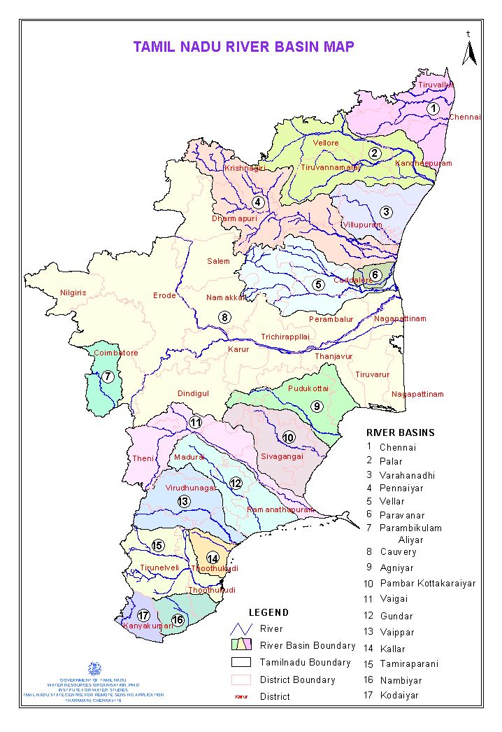
River basins of Tamil Nadu and Water Potential
There are 17 river basins in Tamil Nadu. Cauvery is the only major basin. Of the others, 13 basins are medium and 3 are minor river basins. At 75 percent dependability, the annual surface water generated in the State is 692.78 TMC (19,619 MCM). Table 6.1 detailing the surface water potential in the different districts of Tamil Nadu. The State depends on neighbouring States for considerable quantum of flows, which is about 261.70 TMC (7411 MCM) annually.Table 6.2 indicates the water received from the States of Andhra Pradesh, Karnataka, Kerala and Maharashtra. Thus, the total surface water potential of the State at 75 percent dependability is 954.58 TMC (27,030 MCM).
Following are the rivers which flow through this southernmost region of the Indian peninsula:
- Bhavani River: Fed, mostly, by the southwestern monsoon, this is one of the main tributaries of the river Kaveri.
- Cheyyar River: This tributary of River Palar is a major seasonal river that flows through the district of Tiruvannamalai.
- Chittar River: The main river originates from the Courtallam Hills of the Shencottah Taluk and Tenkasi Taluk in the district of Tirunelveli. It flows through the state along with its 5 tributaries.
- Ponniyar River: Flowing across the borders in between the taluks of Villupuram and Cuddalore, it finally drains into the Bay of Bengal.
- Thamirabarani River: This river originates from the peaks named Agathimalai, Aduppukkal Mottai and Cherumunji Mottai in the Tirunelveli district.
- Vaigai River: While flowing towards the Palk Strait, it changes its course towards the south east near Sholavandan and passes through the town of Madurai.
- Gundar River: It mainly flows through the districts of Tirunelveli and Virudhunagar in Tamil Nadu.
- Noyil River: This tributary of Kaveri flows through Dharapuram taluk and Palladam taluk in Erode district and Coimbatore district respectively.
- Suruli River: This originates from the Suruli Waterfall, which is among the major tourist attractions in the Theni district.
- Vaipar River: With its origination in the bordering hills of the Kerala state, the river runs through the Virudhunagar district as well as the Theni district.
Other Rivers in Tamil Nadu:
To name a few more south Indian rivers serving the inhabitants of the state are given below:
- Addapar River, Adyar River, Agaram Aru River, Aintharuviar River
- Aiyaru River, Aluthakanniar River, Arasalar River, Arichandranathi River
- Arjuna River, Bambar River, Coonoor River, Gadananathi River
- Gingee River, Goddar River, Gomukhi River, Hanumannathi River
- Jambunathi River, Kaattar River, Kabini River, Kallar River
- Kamandala River, Karipottan River, Karunaiyar River, Karuppanathi River
- Kedilam River, Kollidam River, Komugi River, Kothaiyaru River
- Kottagudi River, Kottamalaiyaru River, Koundinya Nathi River, Kowsika River
- Kudamurutti River, Kundar River, Kundha River, Malattar River
- Manimuktha River, Manimuthar River, Markanda River, Mayura River
- Mottaiyar River, Mudikondan River, Mundhal Odai River, Mullaiyar River
- Nandalar River, Naganathi River, Nanganjiyar River, Nattar River
- Odampokki River, Pachaiyar River, Pahrali River, Pamaniyar River
- Pambar River, Pandavaiar River, Parambikulam River, Pykara River
- Rajasingiyaru River, Ramanathi River, Sankaraparani River, Sarabanga River
- Sarugani River, Shanmuganadhi River, Sigur River, Siruvani River
- South Pennar River, Suvetha River, Thennar River, Thenpennai River
- Thirumalairajan River, Thirumanimutharu River, Tondiar River, Uppar River
- Upper Gundar River, Valavaikkal River, Vanniyar River, Varaganathi River
- Vashista River, Vedamaliyaru River, Veera Chozhan River, Vennaaru River
- Vennar River, Vettar River
Source:
1. State Ground Water and Surface Water Resources, Data Centre, Tharamani, Chennai- 113
3. Tamil Nadu Water Supply and Drainage Board